
What Properties Are Being Aligned to the New TOD Zoning?
The purpose of the Transit Oriented Development Alignment Rezoning Initiative is to proactively rezone parcels that exist along the LYNX Blue Line light rail into one of the four new TOD Zoning Districts. These new districts will ensure that the zoning along the Blue Line light rail will be up-to-date with the City of Charlotte’s Station Area Plans. The four zoning districts are the TOD-UC, TOD-NC, TOD-CC, and TOD-TR.
All properties that exist along the LYNX Blue Line were considered for rezoning to one of the new TOD Zoning Districts and most of these properties are being recommended for alignment rezoning. Some of the properties that were not recommended were existing urban conditional zoning, existing uptown mixed-use district, recently approved rezonings to non-urban districts, properties zoned TOD-CC that are not recommended for TOD-UC, and properties that have been submitted for a rezoning but which the Council has made no decision.
TOD-UC: Transit Urban Center
The TOD-UC is for parcels near high-intensity rapid transit stations and streetcar stops. This district will allow for the tallest building heights and will call for the uppermost level of architectural design.
TOD-NC: Transit Neighborhood Center
The TOD-NC will be used for existing or future transit station areas and streetcar stops. This district will allow for the adjustment from the high intensity urban centers to existing neighborhoods especially due to the lower maximum building heights in the City Council’s adopted policy.
TOD-CC: Transit Community Center
The TOD-CC is the district that will be used for parcels near moderate-intensity rapid transit stations and streetcar stops. It will have a lower maximum building height which is intended to encourage development that supports transit in station areas that do not have intense development.
TOD-TR: Transit Transition
The TOD-TR is the district that has the lowest maximum building height and is the least intense district with the most relaxed design standards. The intended use for this district is for it to be used as a transition from the transit community center to the previously established neighborhoods.

Market Study for the Station Areas
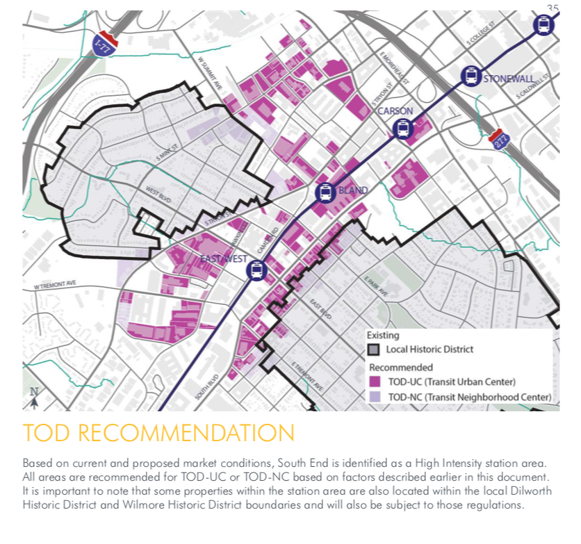
In order to identify the criteria for determining which parcels would be zoned into one of the four districts, Noell Consulting Group performed a market study for the station areas along the LYNX Blue Line. The study showed which station areas will support high-intensity development sufficient for the Transit Urban Center or Transit Neighborhood Center districts. These areas are 36th Street, 25thStreet, Parkwood, and SouthEnd, specifically Carson, Bland, and East-West. The remaining stations, which are recommended for the Transit Community Center and Transit Transition districts, are: J.W. Clay/UNC Charlotte, McCullough, University City Boulevard, Tom Hunter, Old Concord, Sugar Creek, Scaleybark, Woodlawn, Tyvola, Archdale, Arrowood, Sharon Road West, and I-485.
The TOD Alignment Rezoning Guide explains the process used to develop recommendations for rezoning of properties along the LYNX Blue Line. Pictured below are recommendations of each station location. Click here for City of Charlotte’s Interactive Map. Also See how CLT Public Relations can assist you in the TOD Zoning Questions.


Content Authored By: Kristina Beek
CLT Public Relations can assist landowners who are voluntarily or involuntary transitioning their property to a TOD zoning. We provide landowners with Land-Use Advocacy, Property Analysis and Development Evaluation.
Learn how we can advocate for you in the TOD Zoning process.